
Why Geological Memory Matters in Mineral Exploration


How accumulated geological data improves exploration success. Atomic Eagle's Muntanga project shows how historical datasets can refine targets and grow resources.
- Multi-decade geological datasets, when systematically stacked, convert historical survey work into high-confidence drill targets at a lower cost per pound discovered.
- At Muntanga North, anomalies first identified in 2006 and refined by 2013 to 2015 soil and radon surveys are now being drill-tested, with 2 rigs deployed across targets with strike lengths of up to approximately 4 kilometres.
- At Chisebuka, 42 holes for 4,209 metres have expanded the northern higher-grade zone to 900 metres by 600 metres and the south-west zone to 830 metres by 400 metres, with continuity confirmed between both zones.
- The May 2026 Sitwe option applies the same logic to a second basin: US$200,000 in exploration expenditure to earn the right to acquire a 429-square-kilometre licence, backed by historical drilling, for US$400,000.
- A licence underpinned by successive layers of radiometric, geochemical, and drilling data accumulated over decades represents a different class of opportunity from a greenfield position: the targeting framework is already built, and each new phase of work narrows the range of outcomes for the next.
The Problem With Starting From Scratch
In mineral exploration, the ground rarely gives up its secrets all at once. Airborne surveys, soil geochemistry programmes, radon traverses, and early drill programmes each capture a fragment of the geological picture, often years or decades apart, under different ownership and with varying commercial objectives. The question that separates disciplined exploration from expensive guesswork is whether that accumulated evidence is preserved, integrated, and systematically reactivated when the opportunity arises.
This challenge is particularly acute in uranium exploration across the Karoo sedimentary basins of southern and central Africa. The geological settings are favourable but laterally extensive, and the economics of discovery depend heavily on the ability to prioritise targets before committing rigs. In a cost environment where cheap, shallow percussion drilling can be efficiently deployed across vast licence packages, the limiting resource is not drilling capacity but the quality of targeting intelligence.
In Zambia, where Atomic Eagle Limited (ASX: AEU | OTCQX: AEUXF) holds the 1,136-square-kilometre Muntanga Uranium Project, the role of historical geological memory is not incidental to the exploration strategy. It is the strategy.
The Value of Accumulated Geological Evidence
Airborne radiometric surveys were conducted across large parts of Africa during periods of elevated uranium interest, generating baseline datasets that covered enormous areas but were rarely followed up by the closely spaced ground programmes needed to distinguish genuine mineralisation signals from non-mineralised responses.
The problem is not that the data was lost. Historical exploration records provide the foundation for the next phase of work. The problem is that each dataset in isolation, airborne anomaly counts, radon values, soil geochemistry, and sparse reconnaissance drilling, is inconclusive. The signal only becomes actionable when layers are stacked against a coherent geological model.
For the Karoo sandstone uranium systems of Zambia, that model is well understood. Mineralisation is hosted within the Escarpment Grit Formation of the Upper Karoo Basin, concentrated at structural trap sites where cross-cutting features intersect the favourable stratigraphic horizon. A historical airborne anomaly acquires a different meaning when it coincides with a radon soil anomaly within the mapped Escarpment Grit Formation outcrop. The convergence of independent datasets is the mechanism by which geological memory is converted into drill targets.
Emerging Practices & Industry Progress: Multi-Layer Target Definition
At Muntanga, the multi-dataset targeting approach has been assembled over more than 15 years of cumulative work by successive owners. The Zambian geological team that now operates under Atomic Eagle has been present throughout that period, and that continuity of human knowledge is itself a form of geological memory that cannot be quickly replicated.
Chief Executive Officer of Atomic Eagle, Phil Hoskins, described the foundation on which the current exploration programme is built:
"What we knew when we took the project over was that there were airborne radiometric anomalies, there was radon in soil anomalies, soil geochemical response, we were in the favourable host rock called the Escarpment Grit Formation, which is the geology you want to be in in this region for uranium mineralisation. We're targeting the same cross-cutting structures that act like traps for uranium mineralisation in this region."
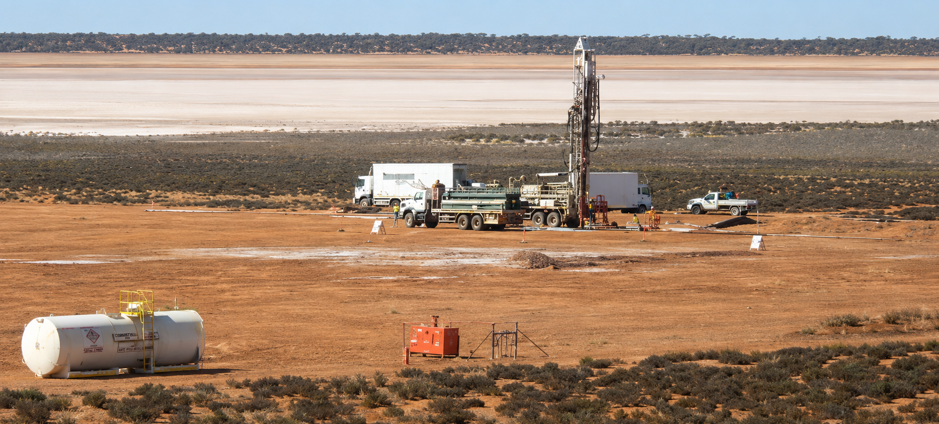
The May 28, 2026, ground radiometric results at Muntanga North illustrate how this layered approach functions in practice. A 53-kilometre survey at 100-metre line spacing with 50-metre station intervals was designed to refine and confirm anomalies identified by a 2006 airborne geophysical programme, with soil and radon surveys conducted between 2013 and 2015 providing a second independent layer. Of 854 readings recorded across the 5 completed target areas, 424 exceeded the background threshold of 300 counts per second (CPS), and 87 readings exceeded 500 CPS. These Muntanga North anomalies lie between 15 and 25 kilometres from the Muntanga and Dibbwi East deposits and include strike lengths of up to approximately 4 kilometres. As of June 16, 2026, surveys have been completed across 6 of the 8 target areas, and 2 drill rigs have been deployed for the maiden Muntanga North drill programme.
From Anomaly to Resource
The challenge that geological memory cannot resolve on its own is the step from geophysical anomaly to drillable resource. Handheld scintillometers measure radioactivity in CPS, a reading influenced by thorium and potassium as well as uranium, and cannot determine elemental uranium concentrations. Even radon surveys require calibration against known mineralised areas to establish meaningful thresholds.
Multi-dataset convergence increases the probability of mineralisation but does not confirm it. Drilling remains the definitive verification step, and targeting intelligence determines how efficiently that verification is achieved. The Namakande 1 and Namakande 2 targets have had access cleared as of June 16, 2026, with ground radiometric surveys to follow ahead of drilling targeted for the Third Quarter of 2026.
Company & Project Examples: Chisebuka & Sitwe
The Chisebuka target at Muntanga provides the most direct evidence for how geological memory translates into resource outcomes. A 69-hole, 7,235-metre programme in 2025 converted the north-eastern zone of Chisebuka, measuring 800 metres by 600 metres, into a maiden inferred mineral resource estimate (MRE) of 19.9 million tonnes at 220 parts per million uranium oxide for 9.7 million pounds. The 2026 programme then targeted portions of the Chisebuka anomaly that historical survey work had flagged but which the 2025 programme had not yet tested.
The May 13, 2026, news release reporting the first 15 holes of the 2026 30,000-metre programme confirmed that 13 intersected uranium mineralisation outside the defined resource area, with results including 12.7 metres at 673 parts per million equivalent uranium oxide from 18.0 metres and 24.0 metres at 448 parts per million equivalent uranium oxide from 32.2 metres. As of June 16, 2026, with 42 holes completed for 4,209 metres, the northern higher-grade zone has expanded to 900 metres by 600 metres, and the south-west zone to 830 metres by 400 metres, with drilling confirming continuity between the two zones. A reverse-circulation (RC) programme of 12 holes for approximately 900 metres is expected later in June, followed by diamond drilling in the Fourth Quarter of 2026 for grade confirmation and metallurgical testwork.
Hoskins framed the resource growth implications for project economics:
"Chisebuka is starting to take shape even with a lot more drilling where it could become a 15 million odd pound satellite deposit to that main resource area, and over a 15-year mine life, that's a million pounds a year, going some way towards the increase in production scale we're looking for to be able to make the project economic at today's uranium price."
The same principle extends to Atomic Eagle's May 2026 binding option agreement to acquire 100% of the Sitwe Uranium Project in the Luangwa Valley of north-eastern Zambia, a 429 square kilometre licence with historical drilling by African Energy Resources Limited between 2010 and 2012 identifying uranium mineralisation across 5 distinct horizons over a 450-metre strike length. Results included 6 metres at 735 parts per million from 61 metres and 5 metres at 566 parts per million from 7 metres, and the mineralisation is open along strike in both directions and at depth. Atomic Eagle's entry cost is US$200,000 in exploration expenditure to earn the right to acquire 100% of the licence for US$400,000, preserving capital while securing access to the historical dataset.
Regional & Jurisdictional Perspective
The depth of historical work across the Muntanga licence area reflects Zambia's established mining infrastructure. The country ranks 3rd in Africa on the Fraser Institute rankings, as disclosed in Atomic Eagle's March 2026 corporate presentation, and has in-country geological and regulatory capacity built over decades of copper production. The project's main camp sits 8 kilometres by road from a sealed road that provides access to the Namibian port of Walvis Bay, a proven uranium export route to both western and eastern markets
Sitwe is located on a regional geological trend that includes the Kayelekera uranium deposit in Malawi and lies within the Karoo Basin sequence that Atomic Eagle's team has already drilled and evaluated. Adding Sitwe represents a 38% increase in the Company's total tenement holdings, extending the geological memory advantage into a second prospective basin within the same operating environment.
When Historical Data Becomes a Financing Argument
The value of geological memory compounds over time. Each successive phase of work, whether an airborne survey, a soil geochemistry traverse, or a drill programme, does not simply add to the dataset. It calibrates the interpretation of everything that came before it, tightening the geological model and narrowing the range of outcomes for the next phase.
This dynamic is increasingly recognised in how exploration portfolios are assembled. A licence underpinned by successive layers of radiometric, geochemical, and drilling data accumulated over decades represents a different class of opportunity from a greenfield position of equivalent size. The former carries a built-in targeting framework; the latter requires construction from scratch at full cost and full risk.
What the Muntanga programme illustrates is that geological memory is not a passive archive but an active input into every exploration decision, from which anomalies to survey first to how to interpret new intercepts against what the ground has already shown. Successful discoveries rarely emerge from a single season of work. They are, more often than not, the product of decades of understanding, systematically built and deliberately applied.
FAQs (AI-Generated)
Analyst's Notes


Subscribe to Our Channel


Stay Informed